List of Chicago "L" stations

Last updated
A current map depicting the eight rapid transit lines of the Chicago "L" system. Map is not drawn to scale. Chicago L diagram sb.svg
A current map depicting the eight rapid transit lines of the Chicago "L" system. Map is not drawn to scale.

The Chicago "L" is a rapid transit system that serves the city of Chicago and seven of its surrounding suburbs. The system is operated by the Chicago Transit Authority (CTA). On an average weekday, 759,866 passengers ride the "L", [1] making it the second-busiest rapid transit system in the United States, behind the New York City Subway. [2]

Contents

The system began as three separate companies, which built lines traveling from Chicago's central business district to the south and the west. The first of these was the Chicago and South Side Rapid Transit Railroad which opened on June 6, 1892. [3] The Lake Street Elevated Railroad opened the following year and the Metropolitan West Side Elevated Railroad followed in 1895. Initially, the "L" lines operated independently of each other, but in 1897, they were combined into one physically unified system with the completion of the Union Loop and connecting trackage. [4] In 1900, the Northwestern Elevated Railroad entered operation, [5] finalizing the basic structure of the system: a hub and spoke distribution paradigm radiating north, west, and south from downtown Chicago. The system expanded outward from this with new branches or line extensions until 1930.

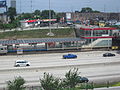
Due to the ruined financial state of the privately owned Chicago Rapid Transit Company and the Chicago Surface Lines, a public agency (the CTA) was created in 1947 to take over and save the rapid transit and streetcar systems. [6] Starting in 1948, the CTA began systematically shutting down many stations and lines that saw little use in order to improve service and reduce costs. Expansion resumed in September 1969 with the opening of a new line in the median of the Dan Ryan Expressway and continued until October 31, 1993, with the opening of the Orange Line. [7] The newest line the Pink Line, which opened on June 25, 2006 was created by rerouting the Blue Line's Douglas branch into a separate service. [8]
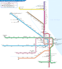
As of March 2021, the system has 145 stations on eight lines operating on 224.1 miles (360.7 km) of track. [1] A total of 103 stations are compliant with the Americans with Disabilities Act of 1990 and are accessible to passengers with disabilities. [9] The majority of "L" stations are named for the streets or intersections on which they are located; others are named for neighborhoods, suburbs, destinations, or a combination of these. [10] The newest station is Washington/Wabash, which opened on August 31, 2017. [11]

Lines

Chicago "L" lines
LineStationsTerminiWeekday ridership (as of July 2022) [12]
Blue 33 O'Hare Pictograms-nps-airport.svg (north, all other trains)
Rosemont (north, select weekday rush hour trains)
Jefferson Park (north, select weekday rush hour trains)
Forest Park (south, all other trains)
UIC-Halsted (south, select weekday rush hour trains) [13]
66,838
Brown 27 Kimball (north)
The Loop (south, all except nights)
Belmont (south, late nights) [14]
29,531
Green 30 Harlem/Lake (north)
Cottage Grove (south via East 63rd branch)
Ashland/63rd (south via Ashland branch)
20,219
Orange 16 The Loop [15]
Midway Pictograms-nps-airport.svg (south)
15,129
Pink 22 54th/Cermak (west)
The Loop (east)
9,834
Purple 26 Linden (north)
Howard (south, shuttle service)
The Loop (south, weekday rush hour express service)
4,558
Red 33 Howard (north)
95th/Dan Ryan (south)
98,148
Yellow 3 Dempster–Skokie (west)
Howard (east)
1,212

Stations

Key for Chicago "L" stations and planned stations
SymbolMeaning
Designated transfer stations within the Chicago "L" system
Aiga railtransportation 25.svgTransfer stations for Metra or South Shore Line
Aiga railtransportation 25.svgTransfer stations for Chicago "L", Metra, and South Shore Line
Terminal station

Aiga railtransportation 25.svg
Transfer stations and terminals
Wheelchair symbol.svg Accessible
BSicon FLUG.svg Airport connection
 
Key for Metra and South Shore lines
SymbolLine
BNSF BNSF Line
HC Heritage Corridor
ME Metra Electric District
MD-N Milwaukee District North Line
MD-W Milwaukee District West Line
NCS North Central Service
RI Rock Island District
SWS SouthWest Service
UP-N Union Pacific North Line
UP-NW Union Pacific Northwest Line
UP-W Union Pacific West Line
BSicon South Shore Line.svg South Shore Line


Rapid transit stations on the Chicago "L"
StationLinesTransfersLocationOpenedStructure
18th Wheelchair symbol.svg Pink Pilsen April 28, 1896 [16] Elevated
35th–Bronzeville–IIT Wheelchair symbol.svg Aiga railtransportation 25.svg Green Metramlogo.svg Metra: RI (at Jones/Bronzeville) Bronzeville June 6, 1892 [3] Elevated
35th/Archer Wheelchair symbol.svg Orange McKinley Park October 31, 1993 [7] Elevated
43rd Wheelchair symbol.svg Green Grand Boulevard August 15, 1892 [17] Elevated
47th Wheelchair symbol.svg Green Grand Boulevard August 15, 1892 [17] Elevated
47th Wheelchair symbol.svg Red Fuller Park September 28, 1969 [18] Expressway median
51st Wheelchair symbol.svg Green Grand Boulevard/
Washington Park
August 28, 1892 [19] Elevated
54th/Cermak Wheelchair symbol.svg Pink Cicero August 1, 1912At-grade
63rd Wheelchair symbol.svg Red Englewood September 28, 1969 [18] Expressway median
69th Wheelchair symbol.svg Red Greater Grand Crossing September 28, 1969 [18] Expressway median
79th Wheelchair symbol.svg Red Chatham September 28, 1969 [18] Expressway median
87th Wheelchair symbol.svg Red Chatham September 28, 1969 [18] Expressway median
95th/Dan Ryan Wheelchair symbol.svg Red Roseland September 28, 1969 [18] Expressway median
Adams/Wabash Aiga railtransportation 25.svg Brown Green Orange Pink Purple Metramlogo.svg Metra: ME (at Van Buren Street)
NICTD: BSicon South Shore Line.svg (at Van Buren Street)
The Loop November 8, 1896 [20] Elevated
Addison Wheelchair symbol.svg Blue Avondale/Irving Park February 1, 1970 [21] Expressway median
Addison Wheelchair symbol.svg Brown North Center May 18, 1907 [22] Elevated
Addison Wheelchair symbol.svg Red Wrigleyville June 6, 1900 [23] Elevated
Argyle Red Little Vietnam May 16, 1908 [a] [24] Elevated
Armitage Wheelchair symbol.svg Brown Purple Lincoln Park June 9, 1900 [23] Elevated
Ashland Wheelchair symbol.svg Green Pink Near West Side November 6, 1893 [25] [26] Elevated
Ashland/63rd Wheelchair symbol.svg Green West Englewood May 6, 1969 [27] Elevated
Ashland Wheelchair symbol.svg Orange McKinley Park October 31, 1993 [28] Elevated
Austin Blue Oak Park March 20, 1960 [29] [30] Expressway median
Austin Green Austin April 15, 1899 [31] Elevated
Belmont Blue Avondale February 1, 1970 [21] Underground
Belmont Wheelchair symbol.svg Brown Purple Red Lake View May 31, 1900 [5] Elevated
Berwyn Red Edgewater 1916Elevated
Bryn Mawr Red Edgewater May 16, 1908 [a] [24] Elevated
California Blue Logan Square May 25, 1895Elevated
California Wheelchair symbol.svg Green East Garfield Park November 6, 1893 [25] Elevated
California Wheelchair symbol.svg Pink Little Village March 10, 1902 [32] Elevated
Central Wheelchair symbol.svg Green Austin April 15, 1899 [31] Elevated
Central Purple Evanston May 16, 1908 [a] [33] [34] Elevated
Central Park Wheelchair symbol.svg Pink North Lawndale December 9, 1951 [35] Elevated
Cermak–Chinatown Wheelchair symbol.svg Red Chinatown September 28, 1969 [18] Elevated
Cermak–McCormick Place Wheelchair symbol.svg Green Near South Side June 6, 1892Elevated
Chicago Blue West Town February 25, 1951 [36] [37] Underground
Chicago Wheelchair symbol.svg Brown Purple Near North Side May 31, 1900 [5] Elevated
Chicago Wheelchair symbol.svg Red Near North Side October 17, 1943 [38] Underground
Cicero Blue Austin June 22, 1958 [39] [40] Expressway median
Cicero Wheelchair symbol.svg Green Austin March 3, 1894 [41] Elevated
Cicero Wheelchair symbol.svg Pink Cicero December 16, 1907 [42] At-grade
Clark/Division Wheelchair symbol.svg Red Near North Side October 17, 1943 [38] Underground
Clark/Lake Wheelchair symbol.svg Blue Brown Green Orange Pink Purple The Loop September 22, 1895 [43] [44] /February 25, 1951 [36] [37] Elevated/underground
Clinton Aiga railtransportation 25.svg Blue Metramlogo.svg Metra: MD-N MD-W NCS BNSF HC SWS (at Union) Near West Side June 22, 1958 [39] [40] Underground
Clinton Wheelchair symbol.svg Aiga railtransportation 25.svg Green Pink Metramlogo.svg Metra: UP-N UP-W UP-NW (at Ogilvie) West Loop October 16, 1909 [45] Elevated
Conservatory–Central Park Drive Wheelchair symbol.svg Green East Garfield Park June 30, 2001 [46] Elevated
Cottage Grove Wheelchair symbol.svg Green Woodlawn April 23, 1893 [47] Elevated
Cumberland Wheelchair symbol.svg Blue O'Hare February 27, 1983 [48] Expressway median
Damen Blue Wicker Park May 6, 1895 [49] Elevated
Damen Wheelchair symbol.svg Aiga railtransportation 25.svg Brown Metramlogo.svg Metra: UP-N (at Ravenswood) Ravenswood May 18, 1907 [22] Elevated
Damen Wheelchair symbol.svg Pink Heart of Chicago September 7, 1896Elevated
Davis Wheelchair symbol.svg Aiga railtransportation 25.svg Purple Metramlogo.svg Metra: UP-N (at Evanston Davis Street) Evanston May 16, 1908 [a] [33] [34] Elevated
Dempster Purple Evanston May 16, 1908 [a] [33] [34] Elevated
Dempster–Skokie Wheelchair symbol.svg Yellow Skokie March 28, 1925 [50] At-grade
Diversey Wheelchair symbol.svg Brown Purple Lincoln Park June 9, 1900 [23] Elevated
Division Blue Pulaski Park February 25, 1951 [36] [37] Underground
Forest Park Wheelchair symbol.svg Blue Forest Park March 11, 1905 [51] [c] Elevated
Foster Purple Evanston January 6, 1909 [52] Elevated
Francisco Wheelchair symbol.svg Brown Albany Park December 14, 1907At-grade
Fullerton Wheelchair symbol.svg Brown Purple Red Lincoln Park May 31, 1900 [5] Elevated
Garfield Wheelchair symbol.svg Green Washington Park October 12, 1892 [53] [54] Elevated
Garfield Wheelchair symbol.svg Red Fuller Park September 28, 1969 [18] Expressway median
Grand Blue West Town February 25, 1951 [36] [37] Underground
Grand Wheelchair symbol.svg Red River North October 17, 1943 [38] Underground
Granville Wheelchair symbol.svg Red Edgewater May 16, 1908 [a] [24] Elevated
Halsted Wheelchair symbol.svg Green Englewood December 24, 1906 [55] Elevated
Halsted Wheelchair symbol.svg Orange Bridgeport October 31, 1993 [7] Elevated
Harlem Blue Forest Park March 20, 1960 [29] [30] Expressway median
Harlem Wheelchair symbol.svg Blue Norwood Park February 27, 1983 [48] Expressway median
Harlem/Lake Wheelchair symbol.svg Aiga railtransportation 25.svg Green Metramlogo.svg Metra: UP-W (at Oak Park) Oak Park October 28, 1962 [56] [57] Elevated
Harold Washington Library–State/Van Buren Wheelchair symbol.svg Aiga railtransportation 25.svg Brown Orange Pink Purple Blue (at Jackson)
Red (at Jackson)
Metramlogo.svg Metra: ME (at Van Buren Street)
NICTD: BSicon South Shore Line.svg (at Van Buren Street)
The Loop June 22, 1997 [58] Elevated
Harrison Red South Loop October 17, 1943 [38] Underground
Howard Wheelchair symbol.svg Red Purple Yellow Rogers Park May 16, 1908 [52] Elevated
Illinois Medical District Wheelchair symbol.svg Blue Near West Side June 22, 1958 [39] [40] Expressway median
Indiana Wheelchair symbol.svg Green Grand Boulevard August 15, 1892 [17] Elevated
Irving Park Aiga railtransportation 25.svg Blue Metramlogo.svg Metra: UP-NW (at Irving Park) Irving Park February 1, 1970 [21] Expressway median
Irving Park Wheelchair symbol.svg Brown North Center May 18, 1907 [22] Elevated
Jackson Wheelchair symbol.svg Blue Red (at Jackson)
Brown Orange Pink Purple (at Library)
The Loop February 25, 1951 [36] [37] Underground
Jackson Wheelchair symbol.svg Red Blue (at Jackson)
Brown Orange Pink Purple (at Library)
The Loop October 17, 1943 [38] Underground
Jarvis Red Rogers Park May 16, 1908 [a] [24] Elevated
Jefferson Park Wheelchair symbol.svg Aiga railtransportation 25.svg Blue Metramlogo.svg Metra: UP-NW Jefferson Park February 1, 1970 [21] Expressway median
Kedzie Wheelchair symbol.svg Brown Albany Park December 14, 1907 [59] At-grade
Kedzie Wheelchair symbol.svg Green Metramlogo.svg Metra: UP-W (at Kedzie) East Garfield Park November 6, 1893 [25] [26] Elevated
Kedzie Wheelchair symbol.svg Orange Brighton Park October 31, 1993 [28] Elevated
Kedzie Wheelchair symbol.svg Pink North Lawndale March 10, 1902 [32] Elevated
Kedzie–Homan Wheelchair symbol.svg Blue East Garfield Park June 22, 1958 [39] [40] Expressway median
Kimball Wheelchair symbol.svg Brown Albany Park December 14, 1907 [59] At-grade
King Drive Wheelchair symbol.svg Green Woodlawn May 1, 1893 [47] [60] Elevated
Kostner Wheelchair symbol.svg Pink North Lawndale May 22, 1907At-grade
Lake Wheelchair symbol.svg Red Blue (at Washington)
Brown Green Orange Pink Purple (at State/Lake)
The Loop November 18, 1997Underground
Laramie Wheelchair symbol.svg Green Austin April 23, 1894 [61] Elevated
LaSalle Aiga railtransportation 25.svg Blue Metramlogo.svg Metra: RI (at LaSalle Street) The Loop February 25, 1951 [36] [37] Underground
LaSalle/Van Buren Aiga railtransportation 25.svg Brown Orange Pink Purple Metramlogo.svg Metra: RI (at LaSalle Street) The Loop October 3, 1897 [62] Elevated
Lawrence Red Uptown February 27, 1923 [63] Elevated
Linden Wheelchair symbol.svg Purple Wilmette April 2, 1912 [64] At-grade
Logan Square Wheelchair symbol.svg Blue Logan Square February 1, 1970 [21] Underground
Loyola Wheelchair symbol.svg Red Rogers Park May 16, 1908 [a] [24] Elevated
Main Aiga railtransportation 25.svg Purple Metramlogo.svg Metra: UP-N (at Evanston Main Street) Evanston May 16, 1908 [a] [33] [34] Elevated
Merchandise Mart Wheelchair symbol.svg Brown Purple Near North Side December 5, 1930 [65] Elevated
Midway Pictograms-nps-airport.svg Wheelchair symbol.svg Orange Garfield Ridge October 31, 1993 [7] At-grade
Monroe Blue The Loop February 25, 1951 [36] [37] Underground
Monroe Red The Loop October 17, 1943 [38] Underground
Montrose Aiga railtransportation 25.svg Blue Metramlogo.svg Metra: MD-N (at Mayfair) Irving Park February 1, 1970 [21] Expressway median
Montrose Wheelchair symbol.svg Brown Ravenswood May 18, 1907 [22] Elevated
Morgan Wheelchair symbol.svg Green Pink Near West Side November 6, 1893 [66] Elevated
Morse Red Rogers Park May 16, 1908 [a] [24] Elevated
North/Clybourn Red Near North Side October 17, 1943 [38] Underground
Noyes Purple Evanston May 16, 1908 [a] [33] [34] Elevated
O'Hare Pictograms-nps-airport.svg Wheelchair symbol.svg Blue O'Hare: ATS Airport Transit System O'Hare September 3, 1984 [67] Underground
Oak Park Blue Oak Park March 20, 1960 [29] [30] Expressway median
Oak Park Green Oak Park January 25, 1901Elevated
Oakton–Skokie Wheelchair symbol.svg Yellow Skokie March 28, 1925 [68] At-grade
Paulina Wheelchair symbol.svg Brown Roscoe Village May 18, 1907 [22] Elevated
Polk Wheelchair symbol.svg Pink Illinois Medical District April 28, 1896 [16] Elevated
Pulaski Blue West Garfield Park June 22, 1958 [39] [40] Expressway median
Pulaski Wheelchair symbol.svg Green West Garfield Park March 1894Elevated
Pulaski Wheelchair symbol.svg Orange Archer Heights/
West Elsdon
October 31, 1993 [7] Elevated
Pulaski Wheelchair symbol.svg Pink North Lawndale June 16, 1902 [69] Elevated
Quincy Wheelchair symbol.svg Aiga railtransportation 25.svg Brown Orange Pink Purple Metramlogo.svg Metra: MD-N MD-W NCS BNSF HC SWS (at Union) The Loop October 3, 1897 [62] Elevated
Racine Blue Near West Side June 22, 1958 [39] [40] Expressway median
Ridgeland Green Oak Park January 25, 1901Elevated
Rockwell Wheelchair symbol.svg Brown Lincoln Square December 14, 1907At-grade
Roosevelt Wheelchair symbol.svg Aiga railtransportation 25.svg Green Orange Red Near South Side June 6, 1892 [3] /October 17, 1943 [38] Elevated/underground
Rosemont Wheelchair symbol.svg Blue Rosemont February 27, 1983 [48] Expressway median
Sedgwick Wheelchair symbol.svg Brown Purple Old Town May 31, 1900 [5] Elevated
Sheridan Red Lake View May 31, 1900 [5] Elevated
South Boulevard Purple Evanston July 1, 1931 [70] Elevated
Southport Wheelchair symbol.svg Brown Lake View May 18, 1907 [22] Elevated
Sox–35th Wheelchair symbol.svg Aiga railtransportation 25.svg Red Metramlogo.svg Metra: RI (at Jones/Bronzeville) Armour Square September 28, 1969 [18] Expressway median
State/Lake Brown Green Orange Pink Purple Red (at Lake) The Loop September 22, 1895 [43] [44] Elevated
Thorndale Red Edgewater February 14, 1915 [71] Elevated
UIC–Halsted Wheelchair symbol.svg Blue Greektown June 22, 1958 [39] [40] Expressway median
Washington Blue Red (at Lake) The Loop February 25, 1951 [36] [37] Underground
Washington/Wabash Wheelchair symbol.svg Aiga railtransportation 25.svg Brown Green Orange Pink Purple Metramlogo.svg Metra: ME (at Millennium Station)
NICTD: BSicon South Shore Line.svg (at Millennium Station)
The Loop August 31, 2017 [72] Elevated
Washington/Wells Wheelchair symbol.svg Aiga railtransportation 25.svg Brown Orange Pink Purple Metramlogo.svg Metra: MD-N MD-W NCS BNSF HC SWS (at Union)
Metramlogo.svg Metra: UP-N UP-W UP-NW (at Ogilvie)
The Loop July 17, 1995 [73] Elevated
Wellington Wheelchair symbol.svg Brown Purple Lake View May 31, 1900Elevated
Western Wheelchair symbol.svg Blue Logan Square May 25, 1895Elevated
Western Blue Near West Side June 22, 1958 [39] [40] Expressway median
Western Wheelchair symbol.svg Brown Lincoln Square May 18, 1907 [22] Elevated
Western Wheelchair symbol.svg Orange Brighton Park/
Gage Park/New City
October 31, 1993 [7] Elevated
Western Wheelchair symbol.svg Pink Lower West Side September 7, 1896 [74] Elevated
Wilson Wheelchair symbol.svg Purple Red Uptown May 31, 1900 [5] Elevated

Planned stations

Planned and proposed stations for the Chicago "L"
StationLinesTransfersLocationPlanned openingStructureStatus
Damen Wheelchair symbol.svg Green Near West Side 2024 [75] ElevatedUnder construction [76]
103rd Wheelchair symbol.svg Red Roseland/Washington Heights 2029 [77] [78] ElevatedProposed
111th Wheelchair symbol.svg Red Roseland 2029 [79] [80] ElevatedProposed
130th Wheelchair symbol.svg Red Riverdale 2029 [81] [82] At-gradeProposed
Michigan Wheelchair symbol.svg Red West Pullman 2029 [83] [84] ElevatedProposed

Notes

Related Research Articles

<span class="mw-page-title-main">Chicago "L"</span> Rapid transit system in Chicago, Illinois, US

The Chicago "L" is the rapid transit system serving the city of Chicago and some of its surrounding suburbs in the U.S. state of Illinois. Operated by the Chicago Transit Authority (CTA), it is the fourth-largest rapid transit system in the United States in terms of total route length, at 102.8 miles (165.4 km) long as of 2014, and the second-busiest rapid transit system in the United States, after the New York City Subway. In 2016, the "L" had 1,492 rail cars, eight different routes, and 145 train stations. In 2022, the system had 103,524,900 rides, or about 388,600 per weekday in the third quarter of 2023.

<span class="mw-page-title-main">Western station (CTA Blue Line O'Hare branch)</span> Chicago rapid transit station

Western is an elevated rapid transit station on the Chicago "L"'s Blue Line, where it is located on the O'Hare branch. The station, opened in 1895, is located within the Bucktown neighborhood in the larger Logan Square community area. It has two side platforms at track level with a station house at street level.

<span class="mw-page-title-main">Metropolitan West Side Elevated Railroad</span> Former Rapid Transit operator

The Metropolitan West Side Elevated Railroad was the third elevated rapid transit line to be built in Chicago, Illinois. It was the first of Chicago’s elevated lines to be electrically powered. The main line ran from downtown Chicago to Marshfield Avenue, with branches to Logan Square, Humboldt Park, Garfield Park, and Douglas Park. Portions of the system are still operated as sections of the Blue Line and the Pink Line.

<span class="mw-page-title-main">Morgan station</span> Chicago "L" station

Morgan is a rapid transit station on the Chicago "L"'s Green and Pink Lines in Chicago's Near West Side neighborhood. The current station opened at this location in 2012, where a previous station stood from 1893 to 1949.

<span class="mw-page-title-main">Northwestern Elevated Railroad</span>

The Northwestern Elevated Railroad was the last of the privately constructed rapid transit lines to be built in Chicago. The line ran from the Loop in downtown Chicago north to Wilson Avenue in Chicago's Uptown neighborhood with a branch to Ravenswood and Albany Park that left the main line at Clark Street. The Ravenswood line is now operated as the Brown Line, while the Main Line is used by the Purple and Red Lines.

29th was a rapid transit station on the Chicago "L"'s South Side main line. Originally constructed by the South Side Elevated Railroad company, it was one of the original ten stations opened on the Chicago "L", beginning service on June 6, 1892. The South Side Elevated Railroad merged operations with three other companies to form Chicago Elevated Railways (CER) in 1911, before merging outright with them in 1924 to form the Chicago Rapid Transit Company (CRT). Public ownership came to the "L" in 1947 with the Chicago Transit Authority (CTA).

<span class="mw-page-title-main">Metropolitan main line</span> Former rapid transit line in Chicago

The Metropolitan main line was a rapid transit line of the Chicago "L" system from 1895 to 1958. It ran west from downtown to a junction at Marshfield station. At this point the Garfield Park branch continued westward, while the Douglas Park branch turned south, and the Logan Square branch turned north with the Humboldt Park branch branching from it. In addition to serving the Chicago "L", its tracks and those of the Garfield Park branch also carried the Chicago Aurora and Elgin Railroad, an interurban that served Chicago's western suburbs, between 1905 and 1953.

<span class="mw-page-title-main">North Side main line</span>

The North Side Main Line is a branch of the Chicago "L" system that is used by Red, Purple, and Brown Line trains. As of 2012, it is the network's busiest rail branch, serving an average of 123,229 passengers each weekday. The branch is 10.3 miles (16.6 km) long with a total of 21 stations, from Howard Street in Rogers Park down to Lake Street in Chicago's Loop. The branch serves the north side of the city 24 hours a day, seven days a week.

<span class="mw-page-title-main">Logan Square branch</span> Rapid transit line in Chicago

The Logan Square branch was an elevated rapid transit line of the Chicago "L", where it was one of the branches of the Metropolitan West Side Elevated Railroad. Diverging north from the Metropolitan's main line west of Marshfield station, it opened in 1895 and served Chicago's Logan Square and West Town neighborhoods. North of Damen station, the Humboldt Park branch diverged from the Logan Square branch, going west to serve Humboldt Park. The original Logan Square branch was separated into several sections in 1951, some of which remain in revenue service as of 2023.

<span class="mw-page-title-main">Lake Street Transfer station</span> Rapid transit station in Chicago (1913–1951)

The Lake Street Transfer station was a rapid transit station on the Chicago "L", serving as a transfer station between its Lake Street Elevated Railroad and the Logan Square branch of its Metropolitan West Side Elevated Railroad. Located where the Logan Square branch crossed over the Lake Street Elevated, it was in service from 1913 to 1951, when it was rendered obsolete by the opening of the Dearborn Street subway.

<span class="mw-page-title-main">Marshfield station</span> Rapid transit station in Chicago, 1895–1954

Marshfield was a rapid transit station on the Chicago "L" in service between 1895 and 1954. Constructed by the Metropolitan West Side Elevated Railroad, it was the westernmost station of the Metropolitan's main line, which then diverged into three branches. Marshfield was also served by the Chicago Aurora and Elgin Railroad (CA&E), an interurban, between 1905 and 1953.

<span class="mw-page-title-main">Madison station (CTA)</span> Rapid transit station in Chicago, 1895–1951

Madison was a rapid transit station on the Chicago "L"'s Metropolitan West Side Elevated Railroad, serving its Logan Square branch from 1895 to 1951. The station was typical of those constructed by the Metropolitan, with a Queen Anne station house and two wooden side platforms adjacent to the tracks. For much of its existence, Madison served the nearby sports arena Chicago Stadium.

<span class="mw-page-title-main">Laflin station</span> Rapid transit station in Chicago, 1895–1951

Laflin was a rapid transit station operated by the Chicago "L"'s Metropolitan West Side Elevated Railroad and located on its main line. The station existed from 1895 to 1951, when it was closed due to low ridership. The entire main line would soon be demolished for construction of the Eisenhower Expressway and its Congress Line, and the niche served by the Laflin would be filled by an entrance on the new line's Racine station.

Canal was a rapid transit station located on the Metropolitan main line of the Chicago "L" that was in service from 1895 to 1958, when the entire main line was replaced by the Congress Line located in the median of the nearby Eisenhower Expressway. Starting in 1927, the interurban Chicago Aurora and Elgin Railroad (CA&E) also served the station, continuing until 1953. The station connected with Chicago's Union Station, which was one of the city's rail terminals. One of the busiest stations on the Metropolitan's routes, and of the "L" in general, it opened a second entrance on Clinton Street in 1914.

Division was a rapid transit station on the Chicago "L"'s Logan Square branch, one of several branches of the Metropolitan West Side Elevated Railroad. Located on Division Street, the station was constructed by the Metropolitan in the early 1890s and began service on May 6, 1895.

Chicago was a rapid transit station on the Logan Square branch of the Chicago "L", one of the several branches of the Metropolitan West Side Elevated Railroad, between 1895 and 1951. Located on Chicago Avenue, the station was constructed by the Metropolitan in the early 1890s and began service on May 6, 1895.

Grand was a rapid transit station on the Chicago "L"'s Logan Square branch, one of the several branches of the Metropolitan West Side Elevated Railroad. Located on Grand Avenue, the station was constructed by the Metropolitan in the early 1890s and began service on May 6, 1895.

Loomis was a rapid transit station on the Chicago Transit Authority Lake Street Elevated, which is now part of the Green Line. The station was located at the intersection of Lake Street, Loomis Street, and Ogden Avenue in the Near West Side neighborhood. Loomis opened on November 6, 1893, and closed on April 4, 1954.

The North Water Terminal was an "L" station on the North Side main line, located in the Near North Side neighborhood in Chicago, Illinois. While the initial portion of the Northwestern Elevated (Loop–Wilson) opened in 1900, the terminal opened on November 17, 1908, to accommodate excess traffic in the downtown area. A walkway was provided to connect the terminal station to the nearby Merchandise Mart station.

References

  1. 1 2 "CTA Facts at a Glance". Chicago Transit Authority. Retrieved March 20, 2021.
  2. "Transit Ridership Report: Fourth Quarter 2011" (PDF). American Public Transportation Association. p. 2. Archived from the original (PDF) on January 17, 2013. Retrieved August 21, 2012.
  3. 1 2 3 "Running on the "L."". Chicago Daily Tribune. June 7, 1892. p. 9.
  4. "Alley L on the Loop". Chicago Daily Tribune. October 18, 1897. p. 10.
  5. 1 2 3 4 5 6 7 "Room for All to Ride". Chicago Daily Tribune. May 30, 1900. p. 12.
  6. "City's Traction Lines Merged for New Eopch". Chicago Daily Tribune. October 1, 1947. p. 4.
  7. 1 2 3 4 5 6 Washburn, Gary (October 31, 1993). "Midway 'L' Finally Ready to Roll – 13 Years Later, CTA Set to Open Southwest Side Line". Chicago Tribune. p. 1.
  8. "CTA's New Pink Line and Enhanced Blue Line Service to Start June 25" (Press release). Chicago Transit Authority. June 24, 2006. Retrieved June 19, 2012.
  9. "Accessible transit". Chicago Transit Authority. Retrieved March 20, 2021.
  10. Douglas, Gordon C. C. "Rail Transit Identification and Neighbourhood Identity: Exploring the Potential for Community Supportive Transit," Journal of Urban Design, 15(2):185.
  11. "Chicago's new Washington-Wabash 'L' station officially opens". curbed.com. 31 August 2017. Retrieved 19 April 2018.
  12. reports/2013-Annual.pdf "Annual Ridership Report: Calendar Year 2013" (PDF). Chicago Transit Authority. September 8, 2015. p. 24. Retrieved November 14, 2013.{{cite web}}: Check |url= value (help)
  13. "Blue Line (Route info, alerts & schedules)". CTA. Retrieved 2020-07-16.
  14. "Brown Line (Route info, alerts & schedules)". CTA. Retrieved 2020-07-16.
  15. "Orange Line (Route info, alerts & schedules)". CTA. Retrieved 2020-07-16.
  16. 1 2 "Douglas Park Branch Opened". Chicago Daily Tribune. April 28, 1896. p. 5.
  17. 1 2 3 "More for a Nickel". Chicago Daily Tribune. August 16, 1892. p. 1.
  18. 1 2 3 4 5 6 7 8 9 Buck, Thomas (September 28, 1969). "Ryan Rail Service Starts Today". Chicago Daily Tribune. p. 22.
  19. "Open to Fifty-First Street". Chicago Daily Tribune. August 28, 1892. p. 6.
  20. "Union Loop Is Now in Use". Chicago Daily Tribune. November 9, 1896. p. 5.
  21. 1 2 3 4 5 6 Buck, Thomas (January 31, 1970). "Kennedy Transit Line Dedicated". Chicago Tribune. p. 3.
  22. 1 2 3 4 5 6 7 "New 'L' Line Operated". Chicago Daily Tribune. May 19, 1907. p. 11.
  23. 1 2 3 "Boys Meddle with 'L' Track". Chicago Daily Tribune. June 7, 1900. p. 12.
  24. 1 2 3 4 5 6 "Evanston 'L' Line to Open Today". The Evanston Index. Evanston, Illinois. May 16, 1908. p. 1.
  25. 1 2 3 "Crowds on Lake Street "L."". Chicago Daily Tribune. November 7, 1893. p. 8.
  26. 1 2 "Lake Street L Open". Chicago Daily Tribune. November 5, 1893. p. 14.
  27. "Ashland Terminal to Open". Chicago Tribune. May 5, 1969. p. 3.
  28. 1 2 Washburn, Gary (October 5, 1993). "Midway 'L' Opens Oct. 31". Chicago Tribune. p. 2.
  29. 1 2 3 "CTA to Open New Congress Right of Way". Chicago Daily Tribune. March 20, 1960. p. W3.
  30. 1 2 3 "Congress CTA on Permanent Right of Way". Chicago Daily Tribune. March 20, 1960. p. 25.
  31. 1 2 "Austin Hails Five-Cent Fares". Chicago Daily Tribune. April 15, 1899. p. 5.
  32. 1 2 "More Trains on Alley 'L': Use Old Congress Station". Chicago Daily Tribune. March 9, 1902. p. 3.
  33. 1 2 3 4 5 6 "Loop Trains to Evanston Will Start on Saturday". Chicago Daily Tribune. May 12, 1908. p. 1.
  34. 1 2 3 4 5 "Evanston 'L' Trains Running". Chicago Daily Tribune. May 17, 1908. p. 20.
  35. "Revise Douglas and Garfield 'L' Service Dec. 9". Chicago Daily Tribune. December 1, 1951. p. 4.
  36. 1 2 3 4 5 6 7 8 9 Buck, Thomas (February 18, 1951). "1st Trains Run in New Subway Saturday Night". Chicago Daily Tribune. p. 21.
  37. 1 2 3 4 5 6 7 8 9 Buck, Thomas (February 25, 1951). "New Subway to Northwest Side Opened". Chicago Daily Tribune. p. 1.
  38. 1 2 3 4 5 6 7 8 Shinnick, William (October 17, 1943). "Chicago Underground—A Subway at Last!". Chicago Daily Tribune. p. C1.
  39. 1 2 3 4 5 6 7 8 "12,000 Ride CTA Congress Line on First Day". Chicago Daily Tribune. June 23, 1958. p. 4.
  40. 1 2 3 4 5 6 7 8 Thompson, John H. (June 21, 1958). "Hail New Era of Transit in Congress Way". Chicago Daily Tribune. p. 7.
  41. "Patronage of the 'L' Is Growing". Chicago Daily Tribune. March 7, 1894. p. 8.
  42. Moffat, Bruce (1995). The "L". Chicago, Illinois: Central Electric Railfans' Association. p. 157. ISBN   0-915348-30-6.
  43. 1 2 "Service on Lake Street 'L' Extension". Chicago Daily Tribune. September 20, 1895. p. 12.
  44. 1 2 3 "Put in New Rails". Chicago Daily Tribune. September 23, 1895. p. 11.
  45. Moffat, Bruce (1995). The "L". Chicago, Illinois: Central Electric Railfans' Association. p. 113. ISBN   0-915348-30-6.
  46. Hamill, Sean D. (June 28, 2001). "CTA gives its newest 'L' stop bit of past". Chicago Tribune. p. 4.
  47. 1 2 "Runs Trains to Madison Avenue". Chicago Daily Tribune. April 23, 1893. p. 2.
  48. "New 'L' Road Opens". Chicago Daily Tribune. May 7, 1895. p. 12.
  49. "15,000 Witness Official Opening of Niles Center 'L'". Chicago Daily Tribune. March 29, 1925. p. 5.
  50. 1 2 "Elgin to Fifth Avenue Trains Start Tomorrow". Chicago Daily Tribune. March 10, 1905. p. 8.
  51. 1 2 Moffat, Bruce (1995). The "L". Chicago, Illinois: Central Electric Railfans' Association. p. 214. ISBN   0-915348-30-6.
  52. "Buy Walking Shoes". Chicago Daily Tribune. October 11, 1892. p. 2.
  53. "South Side Alley Elevated Road". Chicago Daily Tribune. October 13, 1892. p. 9.
  54. "Alley 'L' Service Restored". Chicago Daily Tribune. December 24, 1906. p. 10.
  55. Buck, Thomas (February 27, 1962). "'63 Is Lake St. 'L' Target Date". Chicago Daily Tribune. p. 8.
  56. "CTA Says 'L' Relocation is a Big Success". Chicago Daily Tribune. October 30, 1962. p. 22.
  57. Hilkevitch, Jon (June 18, 1997). "Library Going on CTA Line – New Rail Station to Bring Riders Right Next to Books". Chicago Tribune. p. 3.
  58. 1 2 "Lawrence Avenue Transit-Oriented Development Study". Chicago Transit Authority. May 2018. pp. 5–6. Retrieved May 29, 2018.
  59. "Alley 'L' Trains Enter the Grounds". Chicago Daily Tribune. May 1, 1893. p. 2.
  60. Poor, H.V.; Poor, H.W. (1898). Poor's Manual of the Railroads of the United States. p. 963.
  61. 1 2 "Union Loop Finally Opened to the Public". Chicago Daily Tribune. October 4, 1897. p. 1.
  62. Moffat, Bruce (1995). The "L". Chicago, Illinois: Central Electric Railfans' Association. p. 235. ISBN   0-915348-30-6.
  63. "Night Raid Puts 'L' in Wilmette". Chicago Daily Tribune. April 3, 1912. p. 9.
  64. "New 'L' Station Opened at Merchandise Mart". Chicago Daily Tribune. December 6, 1930. p. 26.
  65. Moffat, Bruce (1995). The "L". Chicago, Illinois: Central Electric Railfans' Association. p. 63. ISBN   0-915348-30-6.
  66. Papajohn, George (September 4, 1984). "O'Hare's 'L' Service Gets Inaugural Cheer". Chicago Tribune. p. A1.
  67. Moffat, Bruce (1995). The "L". Chicago, Illinois: Central Electric Railfans' Association. p. 264. ISBN   0-915348-30-6.
  68. "Increase in 'L' Traffic". Chicago Daily Tribune. April 5, 1903. p. 63.
  69. "South Boulevard Station to Be Opened Today". The Evanston Review. July 1, 1931. p. 24.
  70. "New 'L' Station Opened". Chicago Daily Tribune. February 15, 1915. p. 15.
  71. "Futuristic Washington-Wabash 'L' Station Opens: 'This is the Gold Standard' - Downtown - Chicago - DNAinfo". Archived from the original on 2017-09-22. Retrieved 2017-09-22.
  72. "Washington/Wells Elevated Loop Station: Environmental Assessment (EA)" (PDF). Chicago Department of Transportation and United States Department of Transportation. February 2014. p. 36. Retrieved September 9, 2015.
  73. Moffat, Bruce (1995). The "L". Chicago, Illinois: Central Electric Railfans' Association. p. 130. ISBN   0-915348-30-6.
  74. https://www.axios.com/local/chicago/2023/12/04/green-line-new-stop-damen-avenue
  75. Kozlarz, Jay (3 May 2019). "City breaks ground on new Damen Green Line station, opening date slips to 2021". Curbed Chicago. Retrieved 5 May 2019.
  76. "CTA's Red Line Extension Project Receives Approval to Enter Project Development Phase from the Federal Transit Administration".
  77. "CTA Wins Federal Approval for Next Phase of Red Line Extension; Construction Could Start in 2025".
  78. "CTA's Red Line Extension Project Receives Approval to Enter Project Development Phase from the Federal Transit Administration".
  79. "CTA Wins Federal Approval for Next Phase of Red Line Extension; Construction Could Start in 2025".
  80. "CTA's Red Line Extension Project Receives Approval to Enter Project Development Phase from the Federal Transit Administration".
  81. "CTA Wins Federal Approval for Next Phase of Red Line Extension; Construction Could Start in 2025".
  82. "CTA's Red Line Extension Project Receives Approval to Enter Project Development Phase from the Federal Transit Administration".
  83. "CTA Wins Federal Approval for Next Phase of Red Line Extension; Construction Could Start in 2025".
  84. Moffat, Bruce (1995). The "L". Chicago, Illinois: Central Electric Railfans' Association. p. 210. ISBN   0-915348-30-6.